John Waring Saxton
b.1806, d.1866
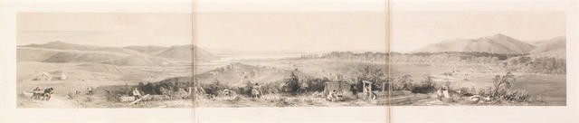
The town and part of the harbour of Nelson in 1842
- 1842
- Lithograph
- Gifted to the Gallery by Christchurch City Libraries, 2005
- 433 x 1608mm
- 2005/073
- View on google maps
Tags: colonization, landscapes (representations), monochrome, mountains, panoramas, people (agents), seas, urban landscapes
This sweeping panoramic view of Nelson depicts industrious European settlers hard at work forging new lives in a new land. Expansion of the settlement took place at a feverish pace and within a year of the first settlers arriving in 1842 numerous dwellings had been built and farming established. Absent from this image, however, are the local Maori who supplied the Europeans with food during the early years of the settlement. Nelson, the second colony for the New Zealand Company, was ideally suited for settlement with its abundant flat land, nearby forests providing timber and safe harbour for shipping. Images such as this served to advertise the New Zealand colony back in Europe. However, within two years the settlers’ demand for land led to the New Zealand Company dispatching surveyors to the nearby Wairau Plains with plans to settle the area. After the surveyors were evicted by local Ngati Toa chiefs, including Te Rauparaha, a group of armed settler militia were sent to arrest the chiefs. The resulting conflict left twenty-two Europeans and four Maori dead, and relations between the two parties in tatters. (Brought to Light, November 2009)